Here are some of our favorite photos from the rest of our vacation. We threw in a photo of our car in Kaka Point for good measure, but after that, the photos are arranged by geography from north (closest to Christchurch) to south (closest to Curio Bay).
Our noble steed: a 2001 Mazda Premacy as seen in Kaka Point.

Farmland in Canterbury, not far south of Christchurch:
The little town of St. Andrews on the coast. As far as we know, there's nothing particularly significant about St. Andrews. It was just representative of the villages we drove through. (Both photo of the town and the ocean below were shot from the same rest stop. And yes, that's the entire town pictured there.)

The town of Oamaru, known for its Victorian architecture and its Blue Penguin colony. The theater is in a covered walkway between the old buildings. We didn't stay long enough in Oamaru to see either the nightly performance of the "Great Storm of 1868" (true story) in the theateror the 180+ penguins coming ashore, but both are things we'd love to do if we get back to Oamaru.


A giant chicken hedge. To give you an idea of scale, the egg is almost as tall as I am.
The famous Moeraki Boulders.


The flower field:
The big, fast flowing Clyde river on the outskirts of the town of Balclutha (which, quite reasonably, means "town on the Clyde").
Kaka Point. Our bed & breakfast "the Molyneux House", its view to the sea, and the rock formation in the surf (90 degree uplifted ancient ocean bed sedimentary layers) 


Nugget Point Lighthouse - It's 250 ft above the water, surrounding by small rocky islands known as the Nuggets. There's a 15 minute walk to get to the lighthouse. The cliffs to either side of the path look tame, but they're actually quite steep as you can make out in the last picture.


Matai Falls. *chuckle* - Just another Department of Conservation stop along the Southern Scenic Route. You really can't drive more than about 20 minutes without seeing the signs pointing to the walks. 
Lake Wilkie - It formed behind sand dunes during the last ice age, and has been there ever since. (There are no streams running into or out of this lake.) For those interested in plants, it apparently shows a complete transition from water side (bog) moss through fully mature forest in only 65 m.
Florence Hill Lookout. Looks over Long Point to the north and Tautuku Beach to the South.

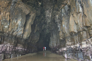
Cathedral Caves. Huge caverns accessible only at low tide. It's about a 15 minute walk down the hill through the rainforest to the beach, and 10 minutes further down the beach. The big fern trees in the forest reminded us of Cousin It.


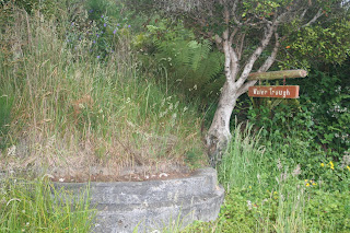
And finally, just before you arrive in Curio Bay, there's the sign that made us laugh the most. I guess with all the amazing scenery... the concete needs to be pointed out!


1 comment:
Wow... this looks like a terrific trip. What more could there be to see? I mean, besides going back for the Penguin crossing and Storm theater. :) Thanks for enjoying NZ for the rest of us.
Post a Comment